Research

WP2 - Sub-pixel mapping of LC gradient info (time series)
What?

Despite the currently available high resolution satellite images, which provide spatially detailed information about urban surface materials, most of the historic archive imagery consists of medium resolution data such as from the Landsat or SPOT programmes. This makes medium resolution images the most suitable data source for urban change analyses with a time perspective of more than ten years.
In this work package, we derived land cover gradient information for the Greater Dublin area from a time-series of four medium resolution satellite images, which were acquired between 1988 and 2001. This land cover gradient information consists of the proportional cover of urban and non-urban surface types within each pixel of the images in the time series.


Why?

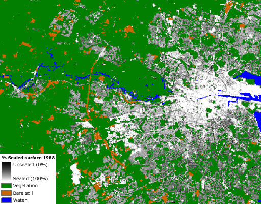
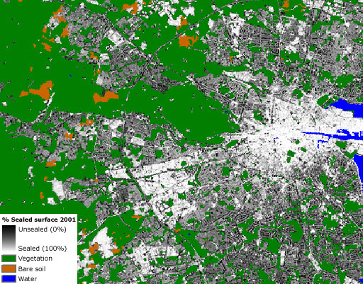
The land cover proportions at each time step, and the gradient information they constitute will be used in work packages 4 and 5 to quantitatively represent the urban spatial structure and composition through spatial metrics. These metrics in turn can be linked to the functional characteristics of the built environment (i.e. land use), can assist the calibration of urban land-use models and help to verify whether the output of these models correctly represents the required spatial patterns. The land cover proportions are also be used to derive calibration parameters for a hydrological run-off model (work package 10).


How?

The land cover gradient information is derived through spectral unmixing, a technique that allows to optimally use the information content of medium or low resolution imagery by representing image pixels that cover multiple land cover types as proportions of these types instead of assigning them to a single dominant land cover class. There are several approaches to the unmixing problem. We applied and compared three techniques: linear spectral unmixing, linear regression analysis and multi-layer perceptrons.            More info ...


Results

The accuracy of the most recent urban mask is estimated by on-screen sampling. Of all validation samples, 93% was assigned to the correct class yielding an overall kappa value of 0.89. The accuracies of the land cover proportions derived by the three unmixing approaches were compared using a validation sample for which temporally filtered reference proportions are collected from the high resolution classification. The mean absolute error of the percentage urban cover fluctuates around 10% for each of the three approaches.
Consequently, linear regression analysis, i.e. the approach which is conceptually the most simple, was selected to produce the definitive output. The resulting land cover gradient information for the time series is further examined in work package 5 to detect irrational changes caused by errors in the interpretation procedure .


Webmaster
Last modification date = 16-03-2009